Enables the saving of lives and preservation of property and resources
Skyward provides customers with systems, tools, and solution architectures, which provide highly automated data collection, processing, analysis, and dissemination capabilities to transform raw data into actionable information for disaster preparedness, response and relief.
Our UAS and geospatial focused solutions address a variety of purposes, including:
Forest Wildland Fire Management
Flooding, Oil Spills, HAZMAT and Other Disasters
Search and Rescue
Forest and Wildlife Management
Military Airbase Resiliency
Power Line Inspection
Skyward leverages its significant defense experience and technical expertise in test & evaluation, unmanned systems, sensor operation and data analysis, machine learning, and research & development to transition existing defense technologies and create new cost-effective, mission-focused solutions for commercial and other government agency customers. Examples include:
Skyward’s SKY-C2 system helps our customers prepare for potential wildfire events and monitor in real-time fire fronts, safe zones, and escape routes, while tracking firefighter locations
Firefighters put their lives on the line even as wildfires increase in size, duration, and frequency. Skyward’s SKY-C2 Wildfire Management System keeps firefighters safe by providing a more complete picture of the fire and where each resource is located.
Utilizing a drone equipped with sensors and radios, the SKY-C2 Wildfire Management System provides real-time information:
- Firefighter locations
- Fire imagery (optical and IR)
- Air traffic
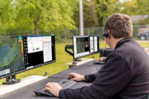
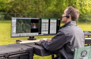
The ground control station allows the incident command center to see where resources are and respond to changes at a moment’s notice.
Each tracking beacon includes a distress button which alerts the incident command center so a response can be mounted.
Skyward’s system optimizes the footprint, cost, and flexibility compared to competitive systems and offers significant technology enhancements over other simple surveillance systems.

Skyward’s SKY-C2 system helps our customers prepare for potential disaster events and monitor disaster response efforts in real-time
Information is invaluable for first responders during a disaster. Skyward’s SKY-C2 Disaster Response System provides critical information to the response team so they can make better decisions faster and stay safe.
increase the ability of researchers and emergency, management personnel to assess the potential and prepare for disasters and first responders to make decisions during disaster events. It addresses the collection, storage, sharing and analysis of relevant data. The system is composed of a ground station, a UAS platform, onboard sensors (visual, infrared, multi-spectral, LiDAR, etc.), and Common Operating Picture (COP) for visualization.
Skyward’s SKY-C2 is addressing the need for a system that enables free exchange of data between different agencies and different COPs, so stovepipes can be avoided during a disaster event response.
Enhances situational awareness and enables greater survivability of firefighting personnel and public property at risk from wildfires.


")
